AI Route Finder Using Agenda-Based Search Algorithms London Underground System
Ziad Tamim / June 24, 2024
In this project, I developed an intelligent route-finding system for the London Underground (Tube) network using classical agenda-based search algorithms. The goal was to design and compare various search methods to effectively traverse a complex transportation graph, optimizing for both the number of stations and travel time. By implementing and evaluating Depth-First Search (DFS), Breadth-First Search (BFS), Uniform Cost Search (UCS), and a heuristic-based Best-First Search, I analyzed their performance in finding optimal routes across the Tube system. The project also extended UCS by incorporating line change penalties to simulate more realistic commuting experiences. The final system demonstrates how traditional AI algorithms can be adapted for intelligent navigation in metropolitan rail systems.
Introduction
Urban transportation networks such as the London Underground are vast and complex, requiring sophisticated algorithms for efficient navigation. Finding an optimal route between two stations involves considering multiple variables including number of stops, total travel time, and line changes. In this project, I built a search-based AI system that addresses this challenge using classical agenda-based search techniques. The project aims to explore the efficiency and trade-offs among various search strategies and to implement enhancements like line-switching penalties and heuristic guidance.
Methodology
Data Loading and Preprocessing
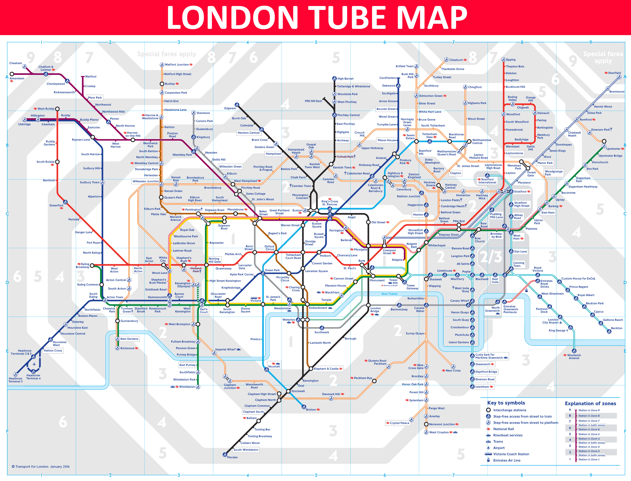
I began by loading a dataset (tubedata.csv) containing station connections, travel costs, and Tube lines.
The data was parsed using Pandas into two dictionaries: one representing station-to-station links (station_dict)
and another capturing zone information (zone_dict). Each station link was bidirectional, and costs represented average travel time between stations.
[StartingStation], [EndingStation], [TubeLine], [AverageTimeTaken], [MainZone], [SecondaryZone], where:
Harrow & Wealdstone, Kenton, Bakerloo, 3, 5, 0

Kenton, South Kenton, Bakerloo, 2, 4, 0- StartingStation: Starting tube station.
- EndingStation: Directly connected tube station.
- TubeLine: Line connecting the stations.
- AverageTimeTaken: Time (in minutes) to travel between the two stations.
- MainZone: Zone of the starting station.
- SecondaryZone: Secondary zone of the starting station (0 if none). Data loaded using Pandas in Python.
Graph Visualization
To visualize the London Tube network, I employed NetworkX and Matplotlib to render a graph where nodes represented
stations and weighted edges denoted travel times. This helped validate the graph structure and offered insights into the connectivity of the network.
Agenda-Based Search Algorithms
1. Breadth-First Search (BFS):
-
Implemented using a queue (deque) to explore nodes level by level.
-
Guaranteed the shortest path in terms of the number of stations.
-
Returned the path, number of stations, total travel time, and nodes expanded.
2. Depth-First Search (DFS):
-
Used a stack to dive deep into one path before backtracking.
-
Did not guarantee optimal path in terms of travel time or station count.
-
Useful for exhaustive exploration of long paths.
3. Uniform Cost Search (UCS):
-
Used a priority queue (heapq) to explore nodes with the lowest cumulative travel time.
-
Guaranteed the optimal path in terms of cost.
4. UCS with Line Change Penalty:
-
Extended UCS by adding a fixed time penalty for switching Tube lines (e.g., 10 minutes).
-
More realistically models actual commuter behavior.
5. Heuristic Best-First Search:
-
Employed a heuristic function based on zone differences between current and goal stations.
-
Prioritized nodes closer to the goal zone.
-
Faster than UCS but not guaranteed to return the optimal path.
Results
BFS
- Path: Mile End → Bethnal Green → Liverpool Street → Bank/Monument → Waterloo → Westminster → Green Park → Oxford Circus
- Stations: 7
- Time: 18 mins
- Nodes Expanded: 70
DFS
- Path: Mile End → Bow Road → ... → Oxford Circus (long detour)
- Stations: 19
- Time: 43 mins
- Nodes Expanded: 43
UCS (Standard)
- Path: Mile End → Bethnal Green → Liverpool Street → ... → Oxford Circus
- Stations: 8
- Time: 16 mins
- Nodes Expanded: 119
UCS (With Line Change Cost)
- Path: Same as standard UCS
- Stations: 8
- Time: 16 mins (optimized with fewer line switches)
- Nodes Expanded: 34
Heuristic Best-First Search
- Path: Mile End → Bethnal Green → ... → Oxford Circus
- Stations: 13
- Time: 30 mins
- Nodes Expanded: 58
Conclusion:
The project demonstrated the application of various search algorithms to the London Underground route-finding problem. While BFS and DFS offered simple approaches to pathfinding, UCS proved to be the most effective in terms of minimizing travel time, particularly when line-change penalties were incorporated. Best-First Search, while faster in some cases, did not consistently outperform UCS in terms of optimality. By implementing and comparing these algorithms, this project showcased how AI-based search methods can be applied to real-world transportation systems to optimize travel efficiency and guide commuters through complex networks.